Backpacking Routes Rhea County, Tennessee, Cumberland Trail
Surveyed local hiking Routes. From 1m on paved flat fields to 25.4m of wooded hills. The shorter hikes being fun all on their own or they could be prep-work for the longer woods hikes on the Cumberland Trail.
- Spring City Nature Park 1-mile loop CLOSED.
- ALT: Roane County Park 1.5-mile loop (next county north).
- Whites Creek Small Wild Area 3-mile loop CLOSED.
- ALT: Foshee Peninsula Small Wild Area 3-mile loop (across the dam).
- Cumberland Trail 8-mile (one-way) Stinging Falls/Soak Creek Trail (Spring City).
- Cumberland Trail 8.5-mile (one-way) Piney River Trail (Spring City) .
- Cumberland Trail up to 25.4-mile-loop Snow/Laurel Falls Trail (Dayton).
Spring City Nature Park

CLOSED. 1m, Nature Park (and future dog park) (fields & paved) in Spring City, TN, is CLOSED due to flood damage after a road tile collapsed. Website.
Alternate: Roane County Park

1.5m, Roane County Park (wooded & paved). Website.
Whites Creek Small Wild Area Trail

CLOSED. 3m loop, TVA’s Whites Creek Small Wild Area Trail in Roddy, TN, Rhea County, is CLOSED due to rockslide across the road, closing the landing and the small wild area that starts at the landing. Website.
Alternate: Foshee Peninsula Small Wild Area Trail
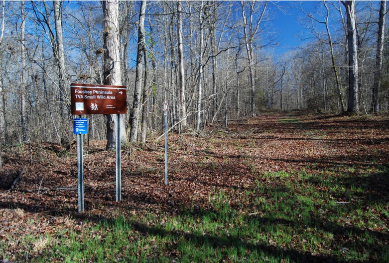
As an alternative to Whites Creek, we can go across the dam, just across the river to another 3-mile loop Foshee Peninsula Small Wild Area maintained by TVA. Website.
Cumberland Trail, Spring City
Stinging Fork Falls/Soak Creek Trail
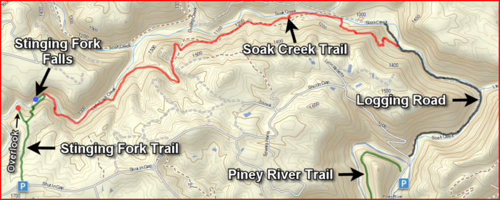
~8m one-way.NEW The Cumberland Trail (from GA to KY, & part of the Great Eastern Trail) has a new segment in Spring City, Rhea County, TN. The Soak Creek Trail connects the Stinging Fork Falls Trail (up on the plateau off Shut-In Gap Road in Spring City, TN) to an abandoned logging road that connects to the north terminus of the Piney River Trail. But don’t look up Soak Creek on the Cumberland Trail Website, it’s not there. You have to look up Stinging Fork Falls Trail.
Driving Directions: From Spring City, TN, take Hwy 68 North to Shut-In Gap Road (a narrow two-lane road with no shoulders). Travel 1.1 miles to the Piney River Management Area parking lot. Across the road is the Piney River Trail trailhead. 0.1 miles further along Shut-In Gap Road on the right to a pull over with a rusty pole gate across an old logging road. This is the north trailhead of Soak Creek Trail.
To get to the South trailhead of Stinging Fork Falls Trail, continue on Shut-In Gap Road. At 1.5 miles from Pine River Management Area parking lot, pass Bonham Baptist Church. At 3.2 miles, pass abandoned Exxon station. At 3.7 miles on right, find the Stinging Falls Forks State Natural Area.
To get to the South trailhead of Piney River Trail, continue on Shut-In Gap Road. At 5.7 miles from Piney River Management Area parking lot, turn LEFT on Newby-Duskin Road, a washed out delapidated logging road.
At 5.8 miles from Piney River Management Area, take the LEFT fork to Newby Rd. This camping area and trailhead for Piney River Trail has NOT been maintained and I don’t recommend driving it with a normal car. A truck maybe. With 4-wheel drive. If you’re careful. I got out and walked.
Fabulous Youtube video of Soak Creek Trail. Youtube of Stinging Fork Falls Trail.
See also Piney Falls Designated State Natural Area.
Piney River Trail
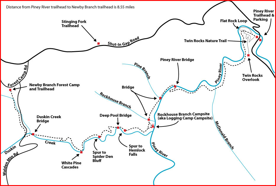
The northern trailheads for both Piney River Trail and Soak Creek are within a few 100 feet of each other along Shut-In Gap Road, although there is parking at both. There is overnight camping with a permit. Website.
Another fabulous youtube tour.
Cumberland Trail, Dayton
Laurel-Snow SNA Section
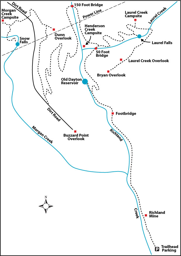
If I read this correctly, from the trailhead to the 150-foot footbridge is 2.1 miles (one-way). So in and out is 4.1 miles if you turn around at the footbridge. If you hike Laurel Falls & out, it’s a total of 9 miles. If you hike to the Bryan Overlook and out is 15.6 miles. If you hike to the footbridge and then take the Snow Falls spur, it’s a total of 14 miles. If you do all of it, Footbridge to Laurel Falls, to Bryan Overlook, back to the footbridge and on to Snow Falls, back to the footbridge and out, it’s a grand total of 25.4 miles. The website suggests getting a permit through the Friends of Cumberland Trail and camping midway to split the hikes over 2 days. These trails are designated MODERATELY STRENUOUS with a 900-foot elevation gain & loss. Website.